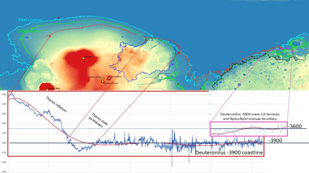
Posting the elevation profiles of the 36 and 39 coastlines reveals a dramatic climb across the Tharsis rise, indicating that at least some of the Tharsis complex inflation is post-Ocean39:
This gets us into a discussion of some complexity, and it has to be taken in a number of steps:
- First Tharsis inflation
- Emplacement of the northern ocean, evidenced by the -3900 shoreline
- Second Tharsis inflation
- Uplift of the paleo-shoreline
- Emplacement of the Tempe Terra slide terrain
- Suppression of the paleo-shoreline opposite the slide terrain resulting from crustal loading
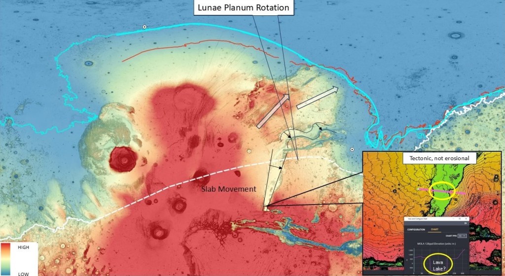
- Separation/rotation/translation of Lunae Planum
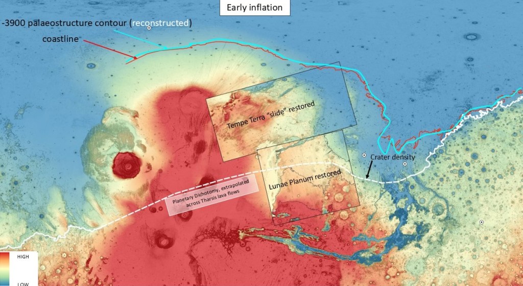
To illustrate these steps by means of a series of slides, we begin with a reconstructed picture of the situation following the initial Tharsis inflation.
The Dichotomy Boundary is extrapolated across the Tharsis Rise, because there is no physical evidence for it, having been resurfaced by successive lava flows.
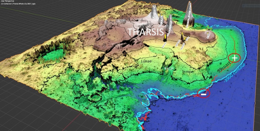
The Northern Ocean and its coastline would normally track the dichotomy fairly closely, but here we see it diverging northward to wrap around the pre-existing Tharsis bulge. The red coastline is fixed, so the blue paleo-structure contour is reconstructed, as being -3900, as it is in the rest of the basin.
The Tempe Terra slide complex is reconstructed back to where it is thought to have originated, repairing the symmetry of the original Tharsis Rise.
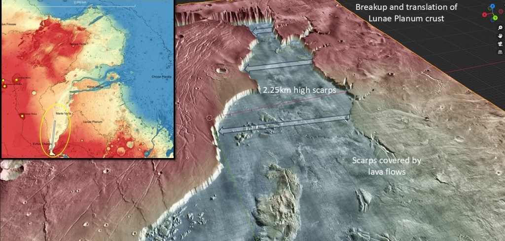
The Lunae Planum slab is also rotated back to its presumed original position, closing the gap between the scarps (shown a few slides ahead); there is a hint of the dichotomy where the crater density falls off to the north, but most of it is overprinted by lava flows.
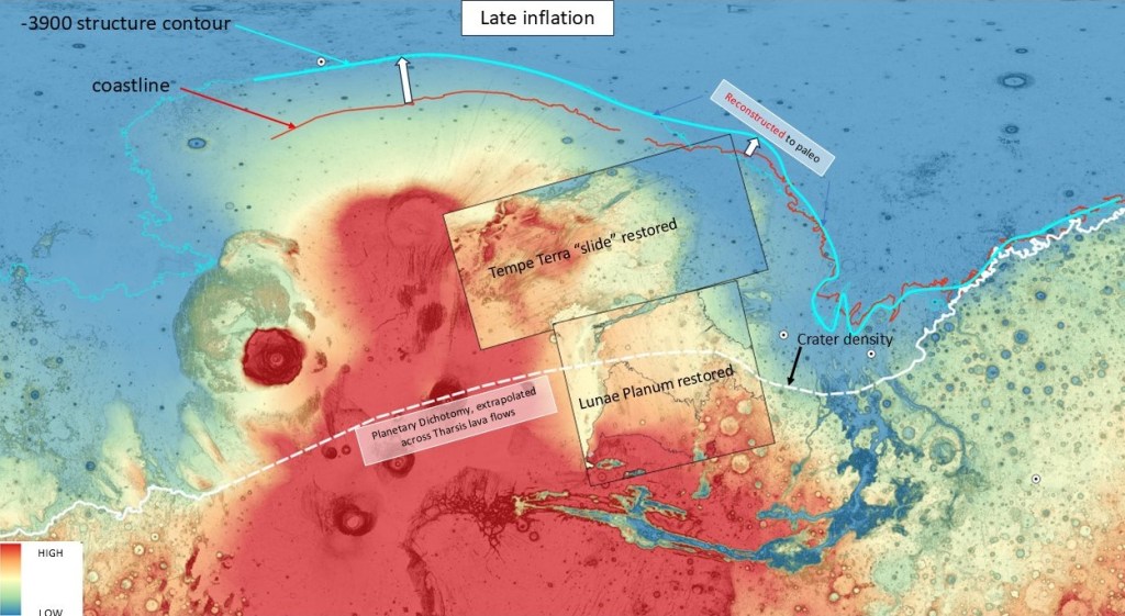
After the second inflation, the coastline is still fixed in the XY plane, but is raised significantly. The -3900 contour is displaced northward with the growing bulge, to its present-day position. The section opposite the Tempe Terra slide is still reconstructed to where it would be post-inflation and pre-slide.
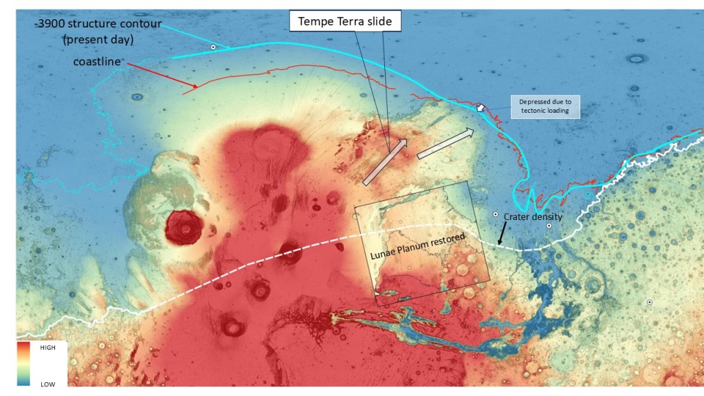
The Tempe Terra slide (maybe in two phases) cuts loose and depresses the crust to bring the -3900 contour to its present location. The coastline is still in the same XY location, but now below -3900m.
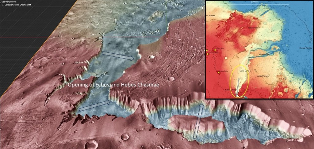
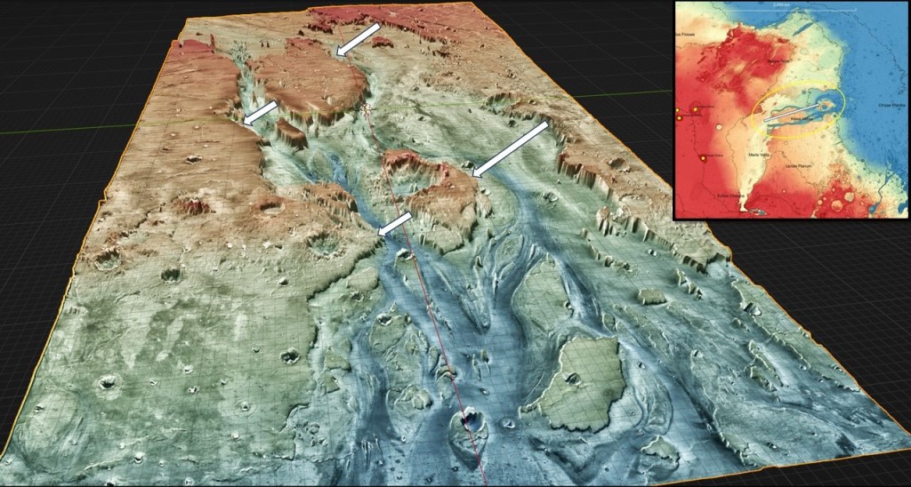
The final act is the opening up of the huge cleft that forms Echus Chasma and Kasai Valles, looking like a failed triple-junction arm. Sheer 2.25km scarps forming both sides, and a flat lava-lake type base indicate its tectonic rather than erosional origin, although later in its history it did support massive outflow channels.
An oblique view toward Echus Chasma, with lava flows obscuring part of the western rim.
Looking North from Hebes and Echus Chasma; perhaps they both opened up at about the same time.
Looking down on Kasai Valles, showing how the pieces fit
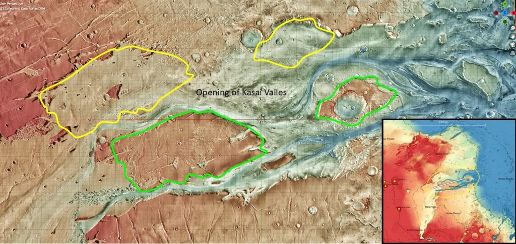
Oblique view of Kasai Valles, indicating the direction of the opening. It subsequently became a huge catchment area for high energy outflow channels.
Summary and Conclusion
Initial rise of the Tharsis volcanic complex caused the -3900 shoreline to form an arc, away from the (overprinted) Dichotomy Boundary. Subsequent inflation uplifted the shoreline and deflected the structure contour northwards. With the increased gradient, a large portion of the complex then slid down the northern flank, depressing the crust, and part of the coastline. At this point the Lunae Planum slab detached, and slid/rotated downdip to its present position.
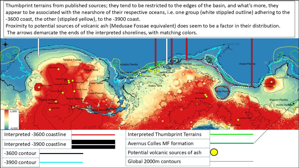
Finally, looking at a regional picture of the interpreted shorelines and their associated thumbprint terrains, the following generalizations can be made: the TP terrains lie just outboard of their respective shorelines, and within reach of potential volcanic sources for the deposition of a Medusae Fossae type caprock; and the fact the same volcanic activity seems to occur for both Ocean36 and Ocean39. This implies a possible link between volcanism and ocean creation, i.e. that climate cycles were determined by volcanism and CO2 out-gassing leading to a dense atmosphere, a water cycle, and glaciation as well as heating of the cryosphere and associated deluges, punctuated by “snowball Earth”-like episodes when the atmosphere was largely lost and water and ice sublimated away. (These cold episodes are analogous to the Sturtian and Marinoan during Earth’s Cryogenian period). Here we have two warming episodes, one filling Ocean36, only to have it sublimate away as the planet cooled after the loss of the greater part of its atmosphere. Subsequently, the Deuteronilus rifting event signifying regional magmatic and volcanic activity, initiated another warming cycle, with a reconstituted atmosphere and a new, lower Ocean39.
This is admittedly a thought experiment and a just-so story (as is most of this presentation). But at least it is testable once we get on the ground there and find real geologic evidence of shorelines, diamictites, cap carbonates, etc
